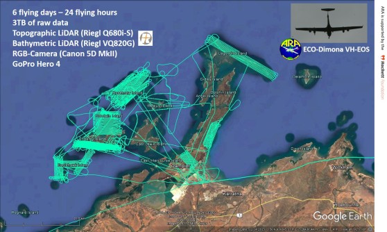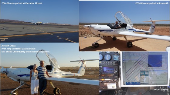
This is the airborne component of the DHSC project. We fly our small research aircraft, an ECO- Dimona motorglider (DIMO) custom-built by Diamond Aircraft in Austria for research flying. The aircraft (VH-EOS and its identical sister ship, VH-OBS) are owned and operated by Airborne Research Australia (ARA) in Adelaide. The ARA is a Not-For-Profit Approved Independent Research Institute. Jorg Hacker is the Director and Chief Scientist of ARA, as well as a Professor of Airborne Environmental Research at Flinders University. Shakti is employed by ARA as field assistant, operating the airborne instrumentation and arranging logistics support.
Our “magic carpet” carries a very comprehensive array of sensors – most importantly two state-of-the-art and powerful airborne LiDARs, one for topographic measurements, the other one for bathymetric measurements, with the latter one also capable of seeing dry surfaces over land. The LiDARs are a Riegl Q680-i-S and a Riegl VQ-820-G, funnily enough also manufactured in Austria, so they fit our aircraft perfectly. Each LiDAR has its own top-of-the-range GPS/IMU system mounted to it to determine the position and attitude (pitch and roll angle and heading) at extremely high accuracy (a few cms for the position and altitude and about 1/100th degree for the angles) 200 times per second. If the reader does not know what an airborne LiDAR is, have a read here. The DIMO also carries a Canon EOS 5D DSLR-camera looking downwards and taking images every few seconds, as well as a GoPro video camera. The instrumentation we carry is worth about $1M, so we better are very careful in what we do with it.
In this Blog, I thought it may be interesting to read how we got from Adelaide to the field site in NW-Australia and back home. This journey is quite different from how the rest of the project team gets there – by taking the airline to Karratha. The way to tell the story is through the regular reports I emailed to the DHSC project team – somewhat shortened as not make this Blog too long.

Excerpts from our trip journal:
Report #1 sent to the DHSC team on 20 Sep (after flying 750km from Adelaide)
I just wanted to let you know that Shakti and I have left Adelaide this morning for Karratha. The past few days have been very hectic and I think it may well be of interest to you to hear what it means to fly very expensive instrumentation in a small aircraft. As some of you know, we had problems with the bathy lidar on the trip preceding this one (mapping mangroves and fishtraps in the Gulf of Carpentaria for 70 flying hours within 3 weeks between Weipa and Groote Eylandt, based out of Burketown). This is not really surprising, because the way we are flying that LiDAR is rather unusual. Normally these instruments are flown in much larger and air-conditioned aircraft, not in a simple pod under the wing of a motorglider. After our return from this trip (on Thu, 7th Sep), we immediately attempted to rectify the problem. With great assistance from Riegl, we have (hopefully) repaired the bathy lidar (treating it with due care) and proved that it works again during a (short) testflight yesterday. The topo lidar had worked perfectly during the Gulf of Carpentaria trip generating more than 3TB of raw data.
Next, we had to do a “quick” change of aircraft. The plan was to perform a 100-hourly maintenance inspection on the same aircraft (VH-OBS) that we used in the Gulf of Carpentaria where it performed flawlessly. However, when we started the inspection, we detected a small fault in its engine which needed to be rectified before flying thousands of kilometers through remote Australia (again) and then being based about 3,000km away from our facilities in Adelaide. To deal with this fault will take about a week, so we decided to transfer the instrumentation to our other aircraft (VH-EOS) – about a 2-day job. And this is what we are flying today.
Report #2 sent to the DHSC team on 22 Sep (after flying 2,100km from Coober Pedy to Broome)
We have now arrived at Broome, our last stop before the final section of the ferry flight planned for tomorrow (from Broome to Karratha, about 650km following the coastline to the WSW).
This trip again illustrated what one faces when ferrying a small research aircraft from the south coast to the north coast of Australia. The flight from Adelaide to Coober Pedy (Australia’s premiere Opal town) was relatively eventless (on the 20th), flying at around 8,500ft into a headwind of sometimes up to 25 knots. In Coober Pedy, we stayed in a nice motel that is constructed in the same way as our own house in the Adelaide hills, the Mud Hut Motel. The people there took the trouble to drive us with our jerry cans twice to the main service station in town, so that we could fill up our tank with Premium Unleaded Petrol. Good.
The next stage of the ferry flight (on the 21st) again required struggling with strong headwinds, so that it took 4.5 hours to reach Alice Springs. The visibility was not great, because there was a lot of smoke and dust in the air. Air Traffic Control in Alice Springs gave us a bit of a “run-around” on arrival, but we arrived safely finding the air temperature at 37deg C – everybody said this is unusual for this time of the year. We refuelled and after having a bit of “fun” starting our engine due to the heat, we were ready for take-off for the next sector – to a cattle station on the edge of the Tanami Desert, Vaughan Springs, also known at Mount Doreen Station. Taking off with a fully laden Dimona in this heat is an interesting “balancing act”. The engine only develops 115HP to lift off an aeroplane weighing 930kg – and that for 5 minutes maximum only. After that it is back to 90HP or less. The engine also gets rather hot during a slow climbing flight, so one needs to be quite carefully monitoring the oil and water temperatures. The Tower was friendly enough to give us the full length of the 3km runway at Alice Springs and when we were very slowly climbing out to the West and hit a thermal at low altitude, they allowed us to circle in this thermal, this way gaining height rather quickly until we reached our cruising altitude of 8,500ft.
The Dimona has so far behaved extremely well giving us no trouble at all. I hope it stays like this.
The plan is to arrive tomorrow in the early afternoon at Karratha and establish ourselves there. Sunday we have planned a day off to start the campaign with a first data capture flight on Monday. I haven’t checked the tides yet….
Report #3 sent to the DHSC team on 23 September:
We made it to Karratha today!
The aircraft is safely tied down, with the nose pointing into the strong wind that slowed us down considerably on our flight from Broome today. This also means that we had strong headwinds for just about the whole 3,500km long ferry flight. Tomorrow we will have a day off and then do the first flight on Monday.
Report #4 sent to the DHSC team on 3 Oct:
This is just to report to you that we have completed all flying here at Karratha. And I can report that everything worked 100%.
I attach an image showing all flightlines for which we have topographic and bathymetric lidar (except the very dense pattern over Enderby and the small dense one directly over Goodwyn Island, where we have very high resolution topographic lidar only. For all of these lines, there are also high resolution RGB-images taken every 4 seconds (approximately 11,000 of them). You will have to look at each one of them ! And we have also really nice GoPro footing for all flights looking vertically down plus several hundred oblique photos out of the window of the aircraft.
The bottom line is – we have collected 2.5TB of raw data.

Report #5 sent to the DHSC team on 5 Oct:
Originally we had planned to fly that task today in the afternoon, but decided that the wind may be friendlier tomorrow morning. So instead we went to one of the beaches looking west across Ningaloo Reef. And there we were presented with a most amazing sight: mating turtles in the surf about 20m from the water’s edge.
Report #6 sent to the DHSC team on 8 Oct:
On the 7th Oct, we laser-scanned the coastline and some underwater areas near Coral Bay, then re-fuelled at Carnarvon before continuing along the coast. Further South, we flew over Hamelin Pool and laser scanned (and photographed) the Stromatolites (I guess everybody knows them…). We re-fuelled and overnighted in Geraldton and then proceeded in rather bad weather to Kalgoorlie. The closer we came to Kalgoorlie, the better the weather became. But not only that – for the first time for the whole trip, we actually encountered better and better tailwinds – a sign of what coming tomorrow on the last leg home.
And his evening we arrived back in Adelaide. We had an incredibly quick flight from Kalgoorlie to Adelaide, 1,711km in about 7 hours, with only one refuelling stop at Forrest in the Nullarbor. We used just 140 litres of Premium Unleaded petrol. Try this with any other means of transport! The flight was so quick, because we had an ever increasing tailwind of up to nearly 100km/h, flying at 3,000m AGL. The attached photograph was typical for what we saw during the flight.
During the whole trip, we flew 67 hours which equals about 10,000km and it took us 18 days.
Thanks for reading this long Blog – more to come.
Jorg

