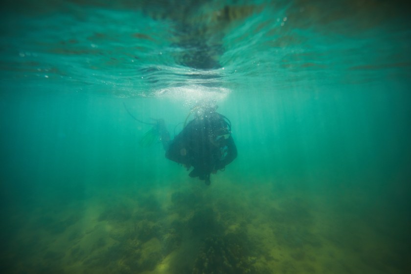
We report Australia’s first confirmed ancient underwater archaeological sites from the continental shelf, located off the Murujuga coastline in north-western Australia. Details on two underwater sites are reported: Cape Bruguieres, comprising > 260 recorded lithic artefacts at depths down to −2.4 m below sea level, and Flying Foam Passage where the find spot is associated with a submerged freshwater spring at −14 m.
The DHSC project team recognises the Murujuga Aboriginal Corporation Council of Elders and Murujuga Land and Sea Rangers Unit as core collaborators on this project.
The DHSC project was supported by the Australian Research Council, Flinders University and the Hackett Foundation. We thank our many colleagues, volunteers, and friends of the project including Ken Mulvaney, Shakti Chakravarty, Victoria Anderson, Sarah de Koning, Hiro Yoshida, Kerry Ludwig, Mads Holst, Sam Wright, Annette George, Tom Allardyce and Graham and Michelle Evans and the AustMarine staff for their support throughout the DHSC project. Further thanks to EGS Surveys and the Pilbara Ports Authority for supplying additional survey data.
Link to the full article published in the Public Libarary of Science (PLOS ONE):
On 23 April 2024, five Murujuga Aboriginal Corporation Rangers took their first ocean dive as part of gaining an PADI Open Water Diver qualification, at Withnell Bay, Murujuga, in the Pilbara, north Western Australia. Funding for the training was provided by the Australian Government through an Australian Research Council grant awarded to Dr John McCarthy of Flinders University and the Deep History of Sea Country team to investigate the uses of technology in searching for submerged heritage sites, including by Traditional Owners and Custodians (Discovery Early Career Researcher Award, DE220100550). While other Rangers were diving, Dr McCarthy, Assistant Ranger Services Manager Peter Cooper and Ranger Glen Aubrey used an underwater remote operated vehicle (ROV) fitted with a camera to see what the divers were up to!
The 2023 George Seddon Memorial Lecture by Mick O’Leary, School of Earth Sciences, The University of Western Australia
There is now a growing recognition (within Western epistemologies) of the existence of Indigenous Underwater Cultural Heritage on Australia’s continental shelf. This recognition stems from an understanding that during the first 50,000 years of occupation, sea levels were up to 130 m lower than today. During this time the continental shelf formed an integral part of the Australian mainland and was occupied by over a thousand generations of people who formed deep cultural connections to this now submerged terrestrial landscape.
Following the termination of the last ice age (circa 20,000 years BP) sea level rise inundated over 2 million square km of land. For the generations of people living though this period, they would have only known retreat, inland and to higher ground. The rising seas inundated their homelands, cutting off spiritually and culturally significant sites, and places whose cultural connections had spanned 10’s of thousands of years.
Therefore, most archaeological data that illuminates these earliest periods of human occupation, dispersal, and subsequent environmental adaptions and technological changes are now drowned on the continental shelves of Sahul (the combined continent of Australia, New Guinea, and Tasmania at times of lower sea-level).
This nascent area of western scientific research is now finally revealing the rich cultural spiritual and material culture contained on Australia’s continental shelf.
Mick O’Leary is a multidisciplinary marine scientist who began his research career exploring the islands and reefs along the tropical North Queensland coast.
His research covers broad themes of climate change, coral reef resilience, and coastal evolution, spanning deep time, the present day, and projections into the future. He has recently broadened his research interests to include the field of submerged landscape archaeology to address knowledge gaps in deep history such as early human migrations, the role of climate in the peopling of Australia and coastal-hinterland cultural exchange.
Although Michael is based in the School of Earth Sciences at the University of Western Australia, his broad research interests mean you will often find him hanging out with an odd assortment of archaeologists, anthropologists, marine ecologists, and oceanographers.
He completed his PhD at James Cook University in 2008 before undertaking postdoctoral research at Manchester Metropolitan and Boston Universities. He has been at UWA since 2018 in a teaching and research academic role.
This annual memorial lecture is presented by the Institute of Advanced Studies and the Friends of the Grounds at The University of Western Australia and honours the life and work of Emeritus Professor George Seddon AM.
George Seddon (1927-2007) was an Emeritus Professor of Environmental Science at the University of Melbourne and a Senior Honorary Research Fellow in English at The University of Western Australia. He was a Fellow of the Royal Australian Planning Institute, the Australian Institute of Landscape Architects, the Australian Academy of Technological Sciences, and the Australian Academy of Humanities. His books include Swan River Landscapes, A Landscape for Learning and Sense of Place. He was awarded the Eureka Prize from the Australian Museum in 1995, the Mawson Medal from the Academy of Science in 1996 and a Lifetime Achievement Award from the Planning Institute of Australia.
The UWA Friends of the Grounds will host light refreshments in the foyer after the event for a gold coin donation.
Proposal description: The proposal is to construct and operate an extension to the Dampier Cargo Wharf at the Port of Dampier. The proposal incorporates the construction of a new (adjoining) southern section of wharf and associated mooring dolphin, dredged berth pocket and vessel manoeuvring area. The Proposal will enable larger vessels (up to Panamax class) to access the terminal and facilitate new trades and products being handled at the Port. Key construction elements of the Project include dredging, blasting, pile driving, stabilisation of the shoreline via construction of rock revetment or a retaining wall and construction of a concrete deck.
The Archaeological / UCH Investigation is available and online via the link above or direct download.
Although this work is not formally affiliated with the DHSC Project, it is an interesting development in the study area of Murujuga Sea Country and further indication that development proponents need to seriously consider Indigenoush Underwater Cultural Heritage.
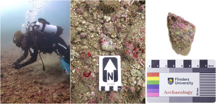
Archaeologist and Scientific Diver, Professor Peter Veth examines artefacts on the seabed (Photos: J. Benjamin)
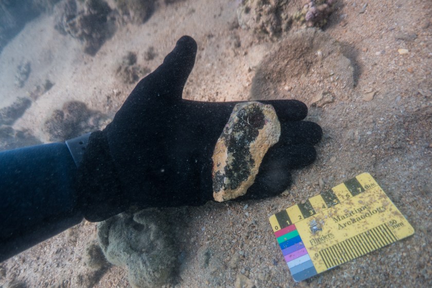
We report the discovery and identification of five ancient stone artefacts associated with a submerged freshwater spring at the underwater archaeological site WH1 in Murujuga (Dampier Archipelago), Western Australia. A limiting date applied to the site based on timing of inundation suggests it was occupied in the Late Pleistocene or Early Holocene. The site is situated well below the intertidal zone having been recorded at 14 m depth in Flying Foam Passage. This discovery highlights the high potential of these submerged springs as archaeological survey targets. We discuss results of a recent survey that expands the number of confirmed artefacts located at WH1 and the geomorphological context in a large calcareous depression associated with a freshwater source. This study demonstrates how submerged landscape research using a suite of technologies can reveal archaeological assemblages in this tropical geomorphological environment, and that adapted techniques could be applied to other tropical conditions such as mangrove coasts, large deltaic plains, or reef-building environments. There are likely thousands of drowned archaeological sites on the continental shelf of the tropics, extending from the intertidal zone to the lowest point of the culturally occupied landmass, at approximately 130 m below modern sea level.